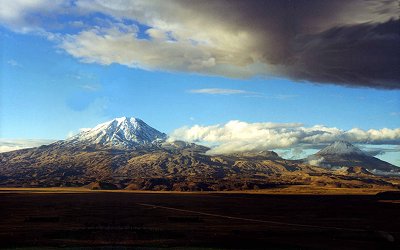
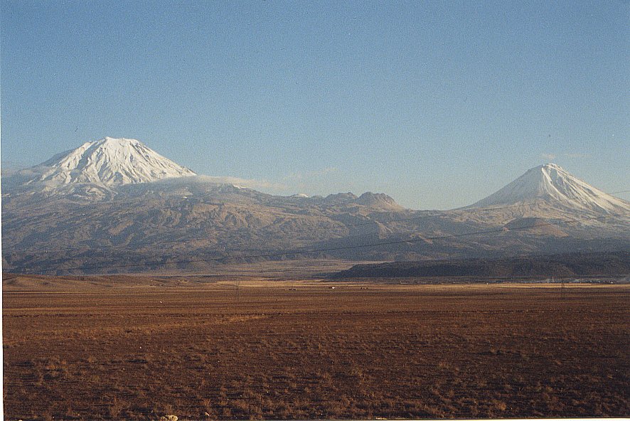
Mount Ararat 1999 - Courtesy Rob Michelson
Urartu/Ararat Boundaries | Ararat Archaeology | Ararat Geology | Noah's Ark Presentation | Ararat Cam | Corona Satellite Image | Expedition List | Explorers of Ararat Book | Explorers List | Eyewitness List | Photo Map | Scale of Ark | Wallpaper
Mount Ararat 1999 - Courtesy Rob Michelson
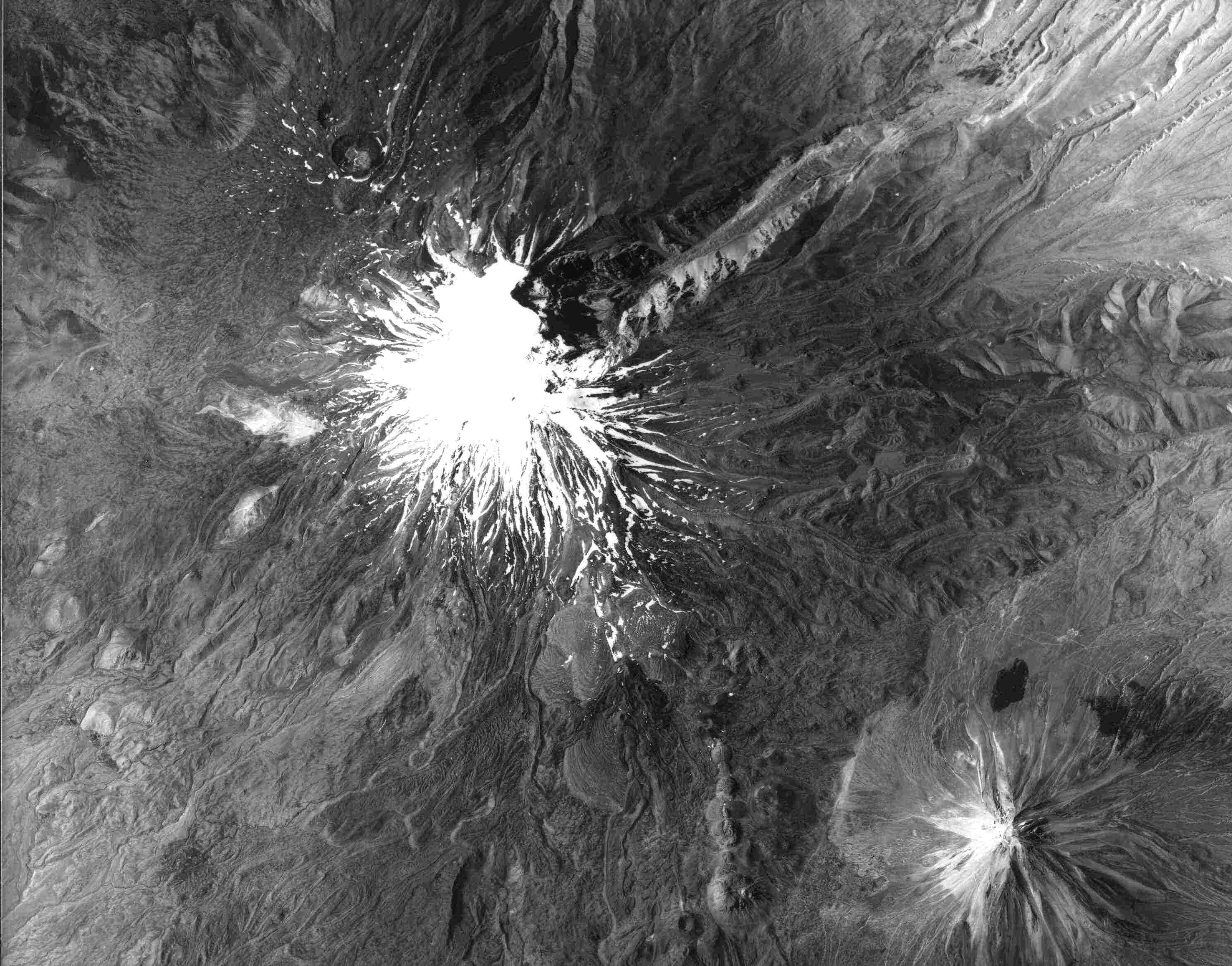
Mount Ararat is located in Eastern Turkey on the borders of Iran, Armenia (formerly U.S.S.R.), and Nakchivan. This volcanic mountain rises 5,165 meters or 16,945 feet high, far above the plains that are at 2,000-3,000 feet high, and is the highest location in the ancient territory of Urartu, a region which covered tens of thousands of square miles with hundreds of mountains. Ararat is the newer Armenian name of Urartu from the Hebrew Torah written by Moses (c. 1400 BC), which only included the consonants "rrt". However, the translators of the Bible replaced the "rrt" with the later name, "Ararat" or "Armenia." The Assyrian kings wrote about battles against the Urartian tribes from the thirteenth century BC (c. 1286 BC) until the sixth century BC when Urartu was destroyed by the Medes. The name Urartu then vanished from history (until archaeologists re-discovered it in the 1800s) and was replaced by Ararat and Armenia in the vicinity as well as in English Bible translations, maps, etc. As history went on in the first and second millenia AD, the mountain became known as Ararat and the region as Armenia. Mount Ararat may be the largest single-mass or volume mountain in the world as it is huge (one really has to see it in person to appreciate its immensity) and rises to 17,000 feet from the plains surrounding it at 2,000-3,000 feet while most other large mountains are in a mountain range with less differential and base circumference. Ararat has only a few native trees growing on it in Ahora village, shrubs around Korhan, and several small forests on Little Ararat. Views differ as to whether Ararat formed much of its size after the flood (post-flood) or partially during the flood with post-flood uplift and lava flows. Some geologists like Clifford Burdick have found pillow lava (lava spewed into water, ice, or snow) up to the 14,000-foot level where the 17-square mile ice cap typically begins. However, since pillow lava may be formed with ice or snow water, it is not a convincing argument for a flood-time mountain creation. Geologists believe that cylindrical and very steep mountains like Little Ararat show that it is most probably a post-flood mountain. There are also claims of fossils and sedimentary layers on Greater Ararat but these claims have not been backed up with concrete evidence as of this date although there are evidence of fossils in the Ararat valley limestones from both the Geologist Abich and the explorers. From 14,000 feet to 17,000 feet, much of the lava is covered by an ice cap which is about 17 square miles in size and is up to 350 feet deep. As computed by ArcImaging, the coordinates that cover the ice cap area on Mount Ararat are N 39 degrees 41' to N 39 degrees 44', E 44 degrees 15' 30" to E 44 degrees 19' 30". The area of this rectangle is about 31.6 square kilometers. The Mount Ararat region along with the Araxes river valley constitutes a possible beginning location for the archaeology of the Early Transcaucasian culture with its distinctive red-black burnished ware. There are a number of Chalcolithic and Early Bronze Age archaeological sites around Mount Ararat in Turkey, Armenia, and Nakchivan. Archaeologists would like to research this area more but the border region is difficult to get permission to research as well as the border breaks up the research area into separate nations... However, ArcImaging was able to secure permission in 2001 for the first archaeological survey of Mount Ararat since the 1980s. The Mount Ararat Archaeological Survey co-authored by Ataturk University Archaeology Professors in Erzurum, Turkey and Rex Geissler of ArcImaging was published in the Summer 2008 Edition of Bible and Spade by Associates for Biblical Research (ABR). Earliest Historical Reference to Noah's Ark being on Mount Ararat The earliest obvious historical reference to the geography surrounding Noah's Ark landing on Mount Ararat is by the early church historian Philostorgius's account around A.D. 425. The 2007 translation of Philostorgius was edited by Philip R. Amidon, originally from Joseph Bidez, except for the extracts from the Syriac chronicles. Amidon emphasizes how Philostorgius made great use of the immense library resources of Constantinople in his writings, which should give us more confidence in his geography. How is it that Philostorgius even knows that the Ark landed on the Armenian Mount Ararat in ca. 425 AD if supposedly (as Bailey et al. contend) no one came up with that idea until medieval times and no one ever made such an identification until then?� Amidon states the following in the introduction about Philostorgius: "The learned and fervently Eunomian layman Philostorgius, born in Cappadocia around 368, heartily detested such historiography as may be imagined [this reference is to the Council of Nicaea's Nicene Creed supporters like Rufinus who translated and extended/massaged Eusebius of Caesarea writings into Latin to show support for Nicene Christianity]. The remnants of his writing show a lively intellectual curiosity encouraged by his sectarian creed, whose God is not the hidden deity of Gnosticism but one whose very substance can be known by human reason directed aright. He obviously drank deeply from the libraries, museums, and archives of Constantinople, his Dissimilarian spectacles bringing into focus a picture of the century preceding that was very unlike the one painted by Rufinus, with whom his own narrative, when he came to write it, was indeed in frequent argument... It appeared sometime between 425 and 433, in twelve books bound in two volumes, its proper period the years from 320 to 425... Philostorgius in fact groups into one 'homoousian' party all those Christians who opposed Eunomianism (in the same way as those of Nicene sympathies like to call 'Arian' anyone who rejected the term 'consubstantial' as used in the Creed of Nicaea)... Such is the central dram of our author's history: the enduring contest between the true monotheistic faith of God's people and the pagan forces arrayed against it. Gnosticism is always the silent partner in the debates between Nicene and Eunomian Christians, the real foe against whom Aetius fought the battle that nearly led to his death. And there is some evidence that this view comes from Eunomius himself. This being the tenor of Philostorgius's history, it is not surprising that the government that championed the Nicene faith would seek to suppress it, seeing that it had previously ordered the burning of the works of Eunomius, one of the great heroes of his tale... He followed Herodotus's lead in historiography, embroidering his narrative with learned excursions into geography and natural history and in general cultivating style that would recommend him to his readers. The style was no empty show. His immersion in the scholarly resources offered by Constantinople has preserved for us, even in the abridgement of its original work, traditions that are otherwise unknown or that add perspective to matters related elsewhere." Philostorgius stated the following about Noah's Ark and Mount Ararat in Book 3 as epitomized by Photius who according to Amidon "is usually a careful, if hostile, epitomizer, and his editorial glosses can usually be detected": "The Persian Gulf, which is formed by the ocean as it enters there, is huge and is encircled by many nations. The Tigris is one fo the enormous rivers that empty their streams into it at its mouth. The Tigris seems to have its source in the east, south of the Caspian Sea in Corduena, and it flows past Syria, but when it arrives in the region of Susa, the Euphrates joins its current to it, and so it boils onward, swollen now to a great size. Hence they say it is called "Tigris" after the animal. But before it descends to the sea, it divides into two great rivers, and then it empties into the Persian Gulf from these two mouths at its end, which are divided from each other. It thus cuts off a considerable area of ground in between, making of it an island that is both of the river and of the sea; it is inhabited by a people called the Mesenes. As for the Euphrates River, it appears to take its rise in Armenia, where Mount Ararat is. The mountain is still called by that name by the Armenians. It is where, according to scripture, the ark came to rest, and they say that considerable remnants of its wood and nails are still preserved there. From there the Euphrates starts as a small stream at first, growing ever larger as it advances and sharing its name with the many rivers that empty into it. It makes its way through Greater and Lesser Armenian and then proceeds on, dividing first the Syria that is properly called Euphratensis and then also the rest of Syria. Having passed through this region, and the remaining part [of Syria], and having broken up the lands through which it passes into a series of convolutions of every sort with its crooked course, it draws near to Arabia. There its way takes it in a circle opposite the Red Sea as it loops around a wide region, after which it turns toward the Caecias wind, midway between north and east. It then heads toward the Tigris River, although it cannot join its whole self to it, but wasting part of itself on the way, it empties the remained of itself into the Tigris quite near Susa, this remainder being a mighty stream quite capable of carrying ships. There it also abandons its name and flows with the Tigris down to the Persian Gulf. The land between these two rivers, the Tigris and Euphrates, is called Mesopotamia." Urartu Archaeological Map Borders (Red) with Urartian Archaeological Sites (Orange) based upon Dr. Paul Zimansky's research Since the upper reaches of this volcanic mountain are covered with broken lava rock everywhere and are currently extremely difficult to ascend or descend, its present state makes it a poor location for Noah's Ark to land and for all the animals to easily descend. Some have theorized if the mountain was lower after the flood and then was uplifted later on with more volcanic activity around the parasitic cones similar to Little Ararat. Yet, Mount Ararat has the bulk of the purported eyewitnesses of the boat-like structure since 1850. These "alleged" eyewitnesses are one reason why the search may continue on the mountain. Given the extensive research which has taken place on Mount Ararat, it seems fair to say that if Noah's Ark ever survived into modern times and is somewhere on Ararat, there are few new places remaining on the mountain to search unless it is buried under the ice cap or lava. There have been many expeditions, accounts, alleged sightings, anomalies, and claims of discovery involving Mount Ararat. What is lacking is any scientific evidence or photo that shows that Noah's Ark survived until today. However, one should also consider the possibility that Noah's Ark landed on Mount Ararat and was subsequently destroyed, which is the possibility alluded to in the article Even If Noah�s Ark Is Not Proven, Noah�s Ark Still Could Have Landed On Mount Ararat. 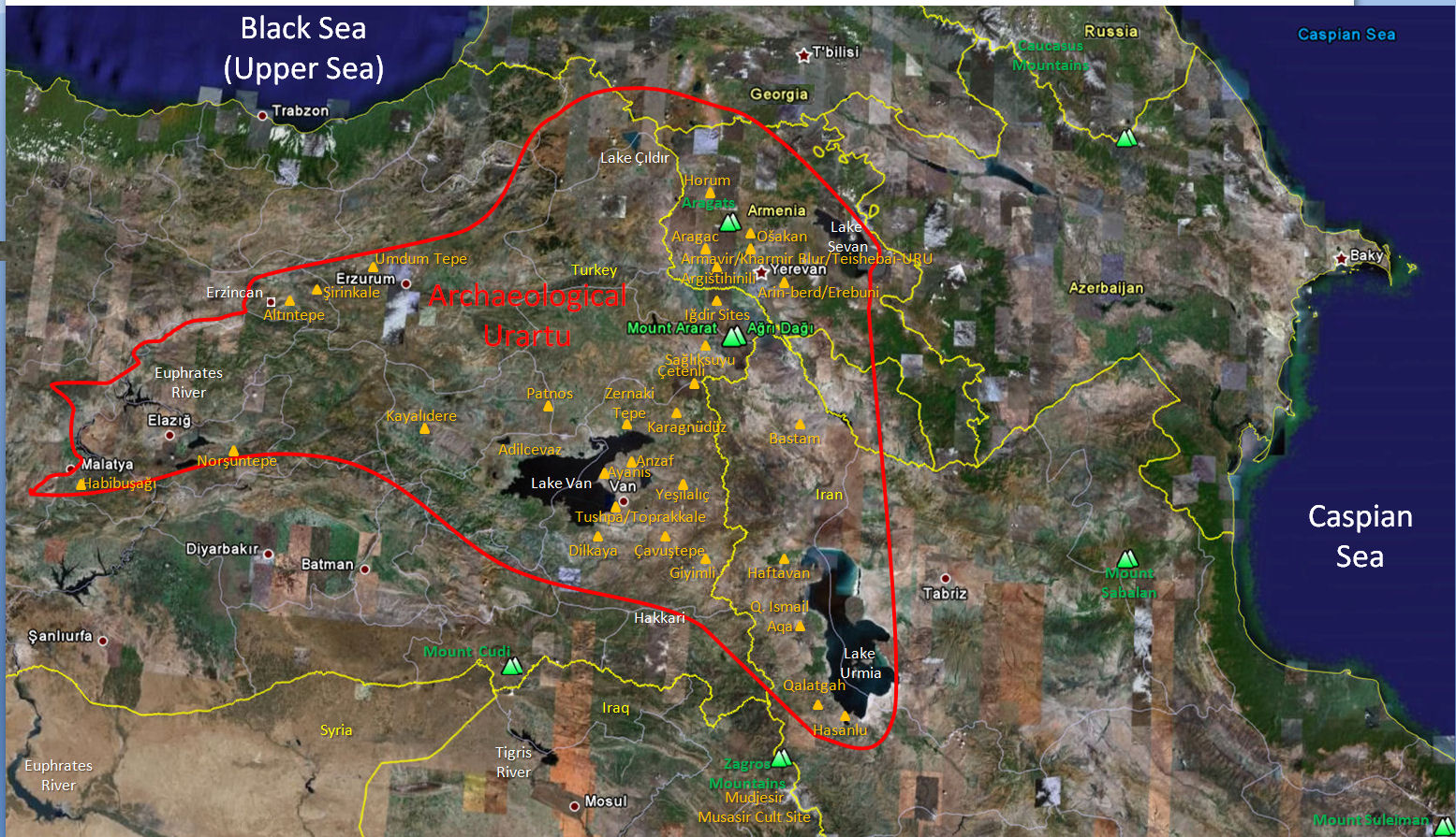
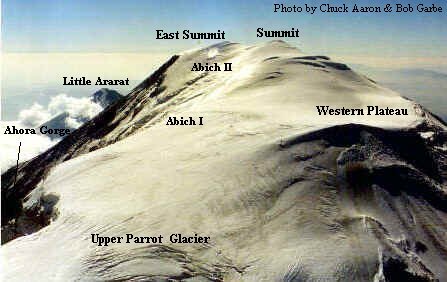
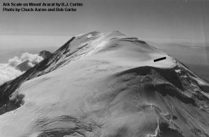
Given all the ground and aerial expeditions (and one with sophisticated mapping capabilities), one should surmise that if the remains of Noah's Ark are indeed on Mount Ararat, they are not in plain view; if the boat is there, it must be buried. There have been 2 attempts that used sub-surface Radar (Ground Penetrating Radar - GPR) technology on Mount Ararat to look under the ice. The 1988 Willis expedition and the 1989 Aaron/Garbe/Corbin expedition used GPR. The 1988 Willis expedition successfully surveyed the eastern summit plateau and the saddle area between the two peaks, concluding there were no Ark remains under the ice. The 1989 expedition was not as successful as the preceding year, where a less-capable GPR system was used in temperate (melting) ice cap conditions on the western plateau of Mount Ararat. However, they were able to determine the ice depth on the western plateau and scale the size of the Ark. As the next generation of commercial RADAR Satellites become available, the GPR will not be needed and it should be clear if any anomalies are underneath the ice cap.
If the remains of Noah's Ark were in moving ice on Mount Ararat (there is only one legitimate glacier, the Black Glacier, though there are other moving ice flows like the so-called Parrot Glacier), the Ark would have been ground to bits. ArcImaging contends that until the entire mountain has been adequately "sub-surface" surveyed using the latest RADAR technology, some people such as the alleged eyewitnesses contended that the Ararat ice cap contains the remains of Noah's Ark since about 90% of the supposed eyewitnesses claim that the boat was sticking out of the ice even though the explorers over the past 50 years did not see the same boat-like structure.
The Urartu/Ararat Boundaries by Rex Geissler, Gordon Franz, and Bill Crouse
Mount Ararat Archaeological Survey by Rex Geissler and Ataturk University Archaeologists
Mount Ararat Geological Survey by Clifford Burdick, Geologist
Search for Noah's Ark Presentation
Review & Critique of Bob Cornuke's Search for Noah's Ark Video in Adobe Acrobat PDF Format - or HTML Web Format by Gordon Franz, Bill Crouse, Rex Geissler
An Armenian Perspective on the Search for Noah's Ark by Rick Lanser, M.Div.
Durupinar's Great Tel�eker Earthflow Geologic Formation by Murat Avci, Geologist
Summary of Alleged Eyewitnesses Ark On Ararat by Michael Castellano
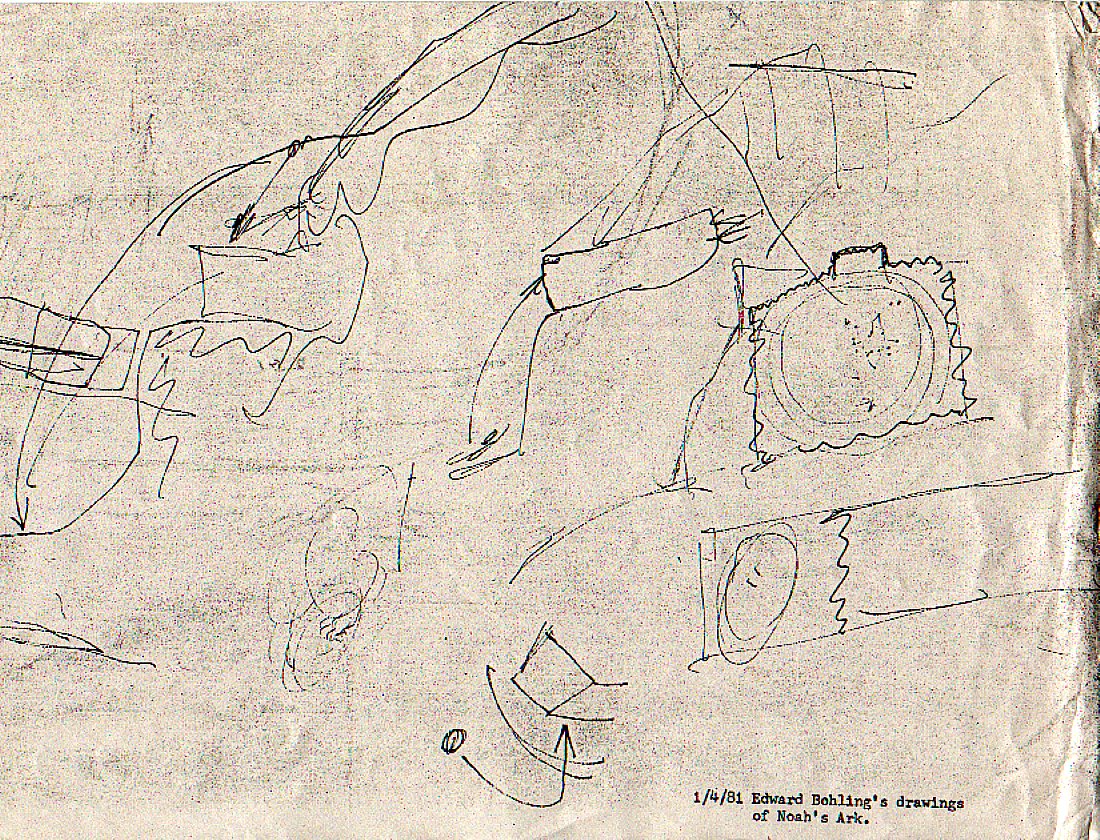
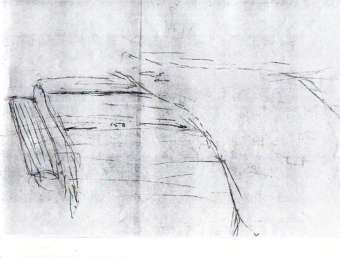
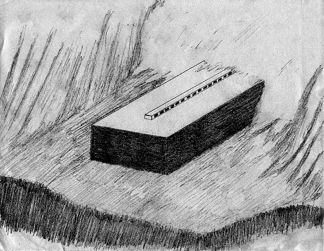
Behling, Ed Sketch #1 1981 of 1973-74 Alleged Sighting
Behling, Ed Sketch #2 1981 of 1973-74 Alleged Sighting
Behling, Ed Sketch #3 1981 of 1973-74 Alleged Sighting
Davis, Ed Account
Davis, Ed Drawings
Hagopian, George Paintings
Hurley, Kevin Newspaper Photo Drawing
Explorers Of Ararat: And the Search for Noah's Ark - 482 page book with 265 photos and all eyewitness accounts
Reshit Account
Stephen, George Account
Todd, William (Bill) Account
U2 Account
Researcher Photos and Information of Mount Ararat and Surrounding Areas The List of Known Expeditions with years and members are listed here. If you have corrections or enhancements for the list, please email us. The following links are to copyrighted photo albums of explorers and researchers around Mount Ararat. Please refer to the FAQs if you would like to attempt to use the photos in any fashion.
Geissler, Rex - Mount Ararat Korhan Archaeological Site Photo Album
Mount Ararat Dogubeyazit Photo Album
Mount Ararat Durupinar Telceker Geological Site Photo Album
Erzurum to Dogubeyazit Silk Road Photo Album
ArcImaging Search for Noah's Ark Online Presentation
Geissler, Rex - Mount Ararat & Turkey Photo Album (395 photos around Turkey and "the mountains of Urartu/Ararat)
Aalten, Gerrit Photo Album (7 photos)
Akcay, Bekir Photo Album
Anderson, Ray Photo Album (5 photos)
Anderson, Ray Website
Angel Rock 2006 Expedition part 1 of 2 by Gerrit Aalten Angel Rock 2006 Expedition part 2 of 2 by Gerrit Aalten Anatolian Fortnight
Ararat Airplane Photo Tour and Photo Album by Bob Stuplich (70 photos)
Ararat Anomaly
Ararat Cam
Bell, Gertrude - 1910 (5 photos and quotes)
Bell, Gertrude - 1910 (Book Amurath to Amurath)
Bowers, Doris Photo Album (21 photos)
Bright, Dick & David Larsen Photo Album (30 photos)
Bryce, James Album
Chantre, Madame 1893 Photo Album (3 photos)
Comber, John's Receding Water Information
Cornuke, Bob Photo Album (Ed Davis Meeting Photo)
Corbin, B.J. Photo Album (41 photos)
Corona Satellite Image
Crews, Larry Korhan Photo Album (16 photos)
Crouse, Bill Ararat Report 1986-1993
Eli Photo Album (3 photos)
Explorers Of Ararat: And the Search for Noah's Ark - 482 page book with 265 photos
Frost, Pat Photo Album (19 photos)
Hong Kong Noah's Ark photos by David Balsiger
Vasken Knouni Website
Kneisler, Matthew Website
Lanser, Rick - An Armenian Perspective on the Search for Noah's Ark presented at the 2007 Near East Archaeological Society Meetings in San Diegoy - Rick Lanser
Larsen, Dave Website
Lee, Elfred Photo Album and Drawings/Paintings of Alleged Noah's Ark based on Eyewitness Interviews with George Hagopian, Ed Davis and Ray Lubeck (3 photos)
Lithuanian Summit Ascent
McIntosh, John Photo Album (54 photos)
Morris, Dr. John Photo Album (199 photos)
Nomads of Ararat #1
Nomads of Ararat #2
Sagliksuyu/Arzap Hole Stones by Gerrit Aalten Sagliksuyu/Arzap Photo Album (6 photos)
Segraves, Kelly The Search for Noah's Ark Book
Simmons, Robin & George Adams Three QuickTime Movies
Simmons, Robin & George Adams Riddle of Ararat Video
Simmons, Robin & George Adams Visions of Ararat Video
Simmons, Robin Fortean Times Article Entitled Forbidden Arkeology
Space Shuttle Image of Ararat
Stuplich, Bob Ararat Airplane Photo Tour and Photo Album (70 photos)
Walking the World
1999 Expedition Summary
Mt.Ararat and Noah's Ark Symposium 4 Report 2006 by Gerrit Aalten
NOTE: There is much more detail and resources in the book The Explorers of Ararat: And the Search for Noah's Ark.
Northeast
The areas of high interest are the Abich II Glacier from between the two summit peaks "the saddle" at 16,500 feet down to 14,000 feet, and then the Ahora Gorge just below. Some information about the Mount Ararat Research Foundation (Aerial Stereophotographic Survey) expedition to the Ahora Gorge page has been added.
Northwest and West Some people believe that the United States Government or Military has information about Noah's Ark. There is no proof about this despite alleged eyewitnesses. Matthew Kneisler, Rex Geissler, Steve Emse, Porcher Taylor and others have created numerous Freedom of Information Act (FOIA) requests. All except the 1949 photos of the Mount Ararat Anomaly have produced no real documentation. Some of the responses are here. ArcImaging does not believe that wood should be sought or promoted as evidence of Noah's Ark since dating will alway be debated. The only reason to search there on Mount Ararat the first place is because of the alleged eyewitesses over the past 150 years and they claimed to see a boat, not pieces of wood. Also, even if the wood was dated "early", there would be no way to prove that this "new" wood was a part of Noah's Ark anyway so it would be extremely controversial and debated.
Some have an interest with an Ararat Anomaly on the rim of the Western Plateau around 15,000 feet. Information and DIA photos regarding this site were obtained by Porcher Taylor using the Freedom of Information Act. Although the CIA statements are interesting, there is nothing visible or very interesting in the photos provided. B.J. Corbin had a suspicion about the Chuchian site, located on the northwest side of Mt. Ararat in a remote canyon at approximately 13,000 feet but believes that the area is too small. The Western Plateau and Parrot Glacier are two areas of interest, especially since many of the local people pointed to this general vicinity when questioned, possibly because Fernand Navarra brought his wood down from the Parrot Glacier area. An ARF expedition with Navarra, Bill Dougall, Alva Appel, and Bud Crawford in 1968 failed to find any wood. However, a SEARCH expedition with Navarra, Elfred Lee, Bud Crawford, and Hugo Neuberg in 1969 did discover small pieces of wood in a melt pond next to the Parrot Glacier in what was termed the Navarra Ice Pack. Navarra's 1950's guide claimed that Navarra planted the 1955 wood on Ararat. This is a possibility since Navarra was on the mountain in 1952 and 1953 before his 1955 discovery and in 1968 before the 1969 discovery. Irregardless of where Navarra's wood originated (both wood samples were analyzed to be of the same tree-type), both 1955 and 1969 wood samples were carbon-dated around 1300-1700 years old, far short of any possible Noah's Ark landing.
Ed Crawford claims a spot near the upper reaches of the Parrot Glacier but there is no evidence that Noah's Ark or a huge man-made structure has survived at this location. As well, an Italian named Angelo Palego claims a spot between the upper reaches of the Parrot Glacier and the Western Plateau at approximately 14,000 feet (4300 meters). However, as with other alleged sites, Palego has provided no scientific evidence to back up his claims. Palego associate and webmaster Francesco Arduini says that after there was some confusion with doctored photographs adding Noah's Ark without proper labeling on a previous website, Palego has now authorized the Official Angelo Palego website.
Eastern Summit Area
In 1988, Dr. Charles Willis virtually eliminated the Eastern Plateau and a portion of the "saddle" area between the two peaks as a possible resting place for Noah's Ark, using sub-surface radar and polar ice drilling.
The proximity to the Iranian and Armenian borders, and the military conflict between Turkish soldiers and terrorists on and near Mount Ararat, make it extremely difficult to obtain permission to do scientific research on the mountain because terrorists like to cross from Iran and hide on the mountain before they go elsewhere in Turkey. Because of this, Mount Ararat is a second-degree military zone and few foreigners have been legally allowed on it since 1990. In 2001, ArcImaging was the first organization to receive Federal Turkish Permission to conduct archaeological research on Mount Ararat since 1990.
If you have valuable information to share or disclose, please contact the Noah's Ark Search.com Research Group or ArcImaging. s